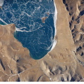
 dry lakebed in the Kalahari Desert. The lake and surrounds are protected today as one of Namibia’s largest wildlife parks. Herds of elephant occupy the dense mopane woodland on the south side of the lake. Mopane trees are common throughout south-central Africa, and host the mopane worm (the larval form of the Mopane Emperor Moth)–an important source of protein for rural communities. According to scientists, about 16,000 years ago, when ice sheets were melting across Northern Hemisphere land masses, a wet climate phase in southern Africa filled Etosha Lake. Today, Etosha Pan is seldom seen with even a thin sheet of water covering the salt pan. This view shows the point where the Ekuma River flows into the salt lake. The Ekuma River is almost never seen with water, but in early 2006 rainfall twice the average amount in the river’s catchment generated flow. Greens and browns show vegetation and algae growing in different depths of water where the river enters the dry lake. Typically, little river water or sediment reaches the dry lake because water seeps into the riverbed along its 250 kilometers (155 miles) course, reducing discharge along the way. In this image, there was enough surface flow to reach the Pan, but too little water reached the mouth of the river to flow beyond the inlet bay. The unusual levels of precipitation also filled several small, usually dry lakes to the north of Etosha Pan.")
WIKIARCHIVES.SPACE
The Human Spaceflight Archive


Information
- Taken in
- Space
- Author
- NASA
- Description
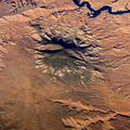
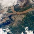
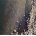
- Ekuma River and Etosha Pan, Namibia are featured in this close-up image photographed by an Expedition 12 crewmember on the International Space Station. Etosha Pan, northern Namibia, is a large (120 kilometers or 75 mile long) dry lakebed in the Kalahari Desert. The lake and surrounds are protected today as one of Namibia’s largest wildlife parks. Herds of elephant occupy the dense mopane woodland on the south side of the lake. Mopane trees are common throughout south-central Africa, and host the mopane worm (the larval form of the Mopane Emperor Moth)–an important source of protein for rural communities. According to scientists, about 16,000 years ago, when ice sheets were melting across Northern Hemisphere land masses, a wet climate phase in southern Africa filled Etosha Lake. Today, Etosha Pan is seldom seen with even a thin sheet of water covering the salt pan. This view shows the point where the Ekuma River flows into the salt lake. The Ekuma River is almost never seen with water, but in early 2006 rainfall twice the average amount in the river’s catchment generated flow. Greens and browns show vegetation and algae growing in different depths of water where the river enters the dry lake. Typically, little river water or sediment reaches the dry lake because water seeps into the riverbed along its 250 kilometers (155 miles) course, reducing discharge along the way. In this image, there was enough surface flow to reach the Pan, but too little water reached the mouth of the river to flow beyond the inlet bay. The unusual levels of precipitation also filled several small, usually dry lakes to the north of Etosha Pan.
- Created on
- Thursday 2 March 2006
- Albums
- ISS (WIP) / EXPEDITIONS / EXPEDITION 12
- Source link
- https://www.flickr.com/photos/nasa2explore/albums/72157634842026003
- Visits
- 12
- Rating score
- no rate
- Rate this photo
- License
- CC BY-NC-ND
- Modified by WikiArchives
- No (original)
- Downloads
- 0
Powered by Piwigo