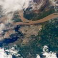
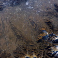
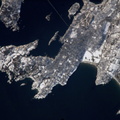
 River. Islands have developed in the Orinoco at a wide sector opposite the city. Guayana is one of the newest cities in Venezuela, having been constructed in 1961 as a new economic growth center for the interior of Venezuela, especially for major industries such as iron, steel, and aluminum. The city stretches 40 kilometers along the south bank of the Orinoco with a population of approximately 800,000 people, one of Venezuela’s largest urban populations. A low barrage (lower left) dams the Caroní as a water supply for the city. The Orinoco River carries brown muddy sediment produced by erosion of the young Andes Mountains far to the southwest. By contrast, the Caroní drains the ancient landscapes of the Guyana Highlands where erosion is so slow that the river water is clear (appearing dark blue) due to a significantly lower sediment load. As at the famous confluence of the brown Amazon and clear Negro rivers in Amazonia, a mixing zone can be seen in the middle of the view, the clear Caroní water producing a less muddy zone for tens of kilometers downstream of the confluence (this part of the Orinoco flows almost due east, left to right).")
WIKIARCHIVES.SPACE
The Human Spaceflight Archive


Information
- Taken in
- Space
- Author
- NASA
- Description
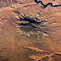
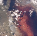
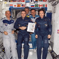
- Ciudad Guayana, Venezuela is featured in this image photographed by an Expedition 12 crew member on the International Space Station. Ciudad Guayana lies on the south bank of the Orinoco River, the second largest in South America, at its confluence with the Caroní (lower left) River. Islands have developed in the Orinoco at a wide sector opposite the city. Guayana is one of the newest cities in Venezuela, having been constructed in 1961 as a new economic growth center for the interior of Venezuela, especially for major industries such as iron, steel, and aluminum. The city stretches 40 kilometers along the south bank of the Orinoco with a population of approximately 800,000 people, one of Venezuela’s largest urban populations. A low barrage (lower left) dams the Caroní as a water supply for the city. The Orinoco River carries brown muddy sediment produced by erosion of the young Andes Mountains far to the southwest. By contrast, the Caroní drains the ancient landscapes of the Guyana Highlands where erosion is so slow that the river water is clear (appearing dark blue) due to a significantly lower sediment load. As at the famous confluence of the brown Amazon and clear Negro rivers in Amazonia, a mixing zone can be seen in the middle of the view, the clear Caroní water producing a less muddy zone for tens of kilometers downstream of the confluence (this part of the Orinoco flows almost due east, left to right).
- Created on
- Thursday 8 December 2005
- Albums
- ISS (WIP) / EXPEDITIONS / EXPEDITION 12
- Source link
- https://www.flickr.com/photos/nasa2explore/albums/72157634842026003
- Visits
- 17
- Rating score
- no rate
- Rate this photo
- License
- CC BY-NC-ND
- Modified by WikiArchives
- No (original)
- Downloads
- 1
Powered by Piwigo