. The close proximity to Texas oilfields led to the establishment of numerous petrochemical refineries along the waterway, such as the Exxon Mobil Baytown installation on the eastern bank of the San Jacinto River. While much of the Ship Channel is associated with heavy industry, two icons of Texas history are also located along its length. A close search of the photo's details reveals both the battleship U.S.S. Texas and the neighboring San Jacinto Monument. The Texas saw service during both World Wars, and is the last remaining example of a dreadnought-class battleship in existence. The nearby San Jacinto Monument commemorates the 1836 battle in which Texas won its independence from Mexico. The monument itself is a 570 feet (173 meters) high shaft topped by a 34 feet (10 meters) high star, making it 15 feet (5 meters) higher than the Washington Monument in Washington, D.C. The Houston Ship Channel has been periodically widened and deepened to accommodate ever-larger ships, and is currently 530 feet (161 meters) wide by 45 feet (14 meters) deep by 50 miles (80 kilometers) long. The islands in the ship channel are part of the ongoing channel widening and deepening project — created by dredge spoils, salt marshes and bird islands are part of the Houston Port Authority’s beneficial use and environmental mitigation responsibilities.")
WIKIARCHIVES.SPACE
The Human Spaceflight Archive


Information
- Taken in
- Space
- Author
- NASA
- Description
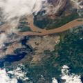
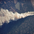
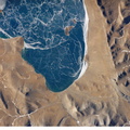
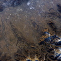
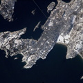
- Houston Ship Channel, Texas is featured in this image photographed by an Expedition 12 crew member on the International Space Station. This view depicts the San Jacinto River portion of the Houston Ship Channel, one of the United States’ busiest sea ports. The Channel provides a conduit between the continental interior and the Gulf of Mexico for both petrochemical products and Midwestern grain. The original watercourse for the Channel, Buffalo Bayou, has its headwaters 30 miles to the west of the city of Houston and has been used to move goods to the sea since at least 1836. Wakes of ships traveling along the channel are visible to the south of the Goat Islands (bright oblong islands at top center of image). The close proximity to Texas oilfields led to the establishment of numerous petrochemical refineries along the waterway, such as the Exxon Mobil Baytown installation on the eastern bank of the San Jacinto River. While much of the Ship Channel is associated with heavy industry, two icons of Texas history are also located along its length. A close search of the photo's details reveals both the battleship U.S.S. Texas and the neighboring San Jacinto Monument. The Texas saw service during both World Wars, and is the last remaining example of a dreadnought-class battleship in existence. The nearby San Jacinto Monument commemorates the 1836 battle in which Texas won its independence from Mexico. The monument itself is a 570 feet (173 meters) high shaft topped by a 34 feet (10 meters) high star, making it 15 feet (5 meters) higher than the Washington Monument in Washington, D.C. The Houston Ship Channel has been periodically widened and deepened to accommodate ever-larger ships, and is currently 530 feet (161 meters) wide by 45 feet (14 meters) deep by 50 miles (80 kilometers) long. The islands in the ship channel are part of the ongoing channel widening and deepening project — created by dredge spoils, salt marshes and bird islands are part of the Houston Port Authority’s beneficial use and environmental mitigation responsibilities.
- Created on
- Monday 28 November 2005
- Albums
- ISS (WIP) / EXPEDITIONS / EXPEDITION 12
- Source link
- https://www.flickr.com/photos/nasa2explore/albums/72157634842026003
- Visits
- 16
- Rating score
- no rate
- Rate this photo
- License
- CC BY-NC-ND
- Modified by WikiArchives
- No (original)
- Downloads
- 0
Powered by Piwigo