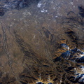
 - by way of the Desaguadero River (muddy area at the north end of the lake). Because Lake Poopo is very high in elevation (roughly 3400 meters or 11,000 feet above sea level), very shallow (generally less than 3 meters or 9 feet), and the regional climate is very dry, small changes in precipitation in the surrounding basin have large impacts on the water levels and areal extent of Lake Poopo. When the lake fills during wet periods, Poopo drains from the south end into Salar de Coipasa (not shown). Water levels in Poopo are important because it is one of South America’s largest saline lakes, and a prime stop for migratory birds, including flamingoes. Last November, water levels had dropped, exposing large tracts of salt and mud flats. A wet and cool period between December and the end of February resulted in flooding of Poopo with muddy waters from the Desaguadero River. NASA managers have tasked the station crew to track such changes, which are related to regional weather patterns. Lake Poopo’s sensitivity to precipitation in the high Andes (possibly reflecting larger climate cycles) provides an excellent visual indicator of these trends.")
WIKIARCHIVES.SPACE
The Human Spaceflight Archive
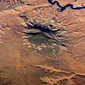
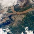
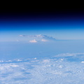
A portion of Lake Poopo is featured in this image photographed by an Expedition 12 crewmember on the International Space Station. Lake Poopo sits high in the Bolivian Andes, catching runoff from its larger neighbor to the north - Lake Titicaca (not shown) - by way of the Desaguadero River (muddy area at the north end of the lake). Because Lake Poopo is very high in elevation (roughly 3400 meters or 11,000 feet above sea level), very shallow (generally less than 3 meters or 9 feet), and the regional climate is very dry, small changes in precipitation in the surrounding basin have large impacts on the water levels and areal extent of Lake Poopo. When the lake fills during wet periods, Poopo drains from the south end into Salar de Coipasa (not shown). Water levels in Poopo are important because it is one of South America’s largest saline lakes, and a prime stop for migratory birds, including flamingoes. Last November, water levels had dropped, exposing large tracts of salt and mud flats. A wet and cool period between December and the end of February resulted in flooding of Poopo with muddy waters from the Desaguadero River. NASA managers have tasked the station crew to track such changes, which are related to regional weather patterns. Lake Poopo’s sensitivity to precipitation in the high Andes (possibly reflecting larger climate cycles) provides an excellent visual indicator of these trends.


Information
- Taken in
- Space
- Author
- NASA
- Description
-
A portion of Lake Poopo is featured in this image photographed by an Expedition 12 crewmember on the International Space Station. Lake Poopo sits high in the Bolivian Andes, catching runoff from its larger neighbor to the north - Lake Titicaca (not shown) - by way of the Desaguadero River (muddy area at the north end of the lake). Because Lake Poopo is very high in elevation (roughly 3400 meters or 11,000 feet above sea level), very shallow (generally less than 3 meters or 9 feet), and the regional climate is very dry, small changes in precipitation in the surrounding basin have large impacts on the water levels and areal extent of Lake Poopo. When the lake fills during wet periods, Poopo drains from the south end into Salar de Coipasa (not shown). Water levels in Poopo are important because it is one of South America’s largest saline lakes, and a prime stop for migratory birds, including flamingoes. Last November, water levels had dropped, exposing large tracts of salt and mud flats. A wet and cool period between December and the end of February resulted in flooding of Poopo with muddy waters from the Desaguadero River. NASA managers have tasked the station crew to track such changes, which are related to regional weather patterns. Lake Poopo’s sensitivity to precipitation in the high Andes (possibly reflecting larger climate cycles) provides an excellent visual indicator of these trends.
- Created on
- Thursday 9 March 2006
- Albums
- ISS (WIP) / EXPEDITIONS / EXPEDITION 12
- Source link
- https://www.flickr.com/photos/nasa2explore/albums/72157634842026003
- Visits
- 14
- Rating score
- no rate
- Rate this photo
- License
- CC BY-NC-ND
- Modified by WikiArchives
- No (original)
- Downloads
- 0
Powered by Piwigo