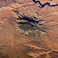
; side canals; and several new fields in the Egyptian desert northwest of Lake Nasser. Astronauts, cosmonauts and space-based sensors have been monitoring these developments in Egypt since their inception in the late 1990s. New Valley’s Toshka Lakes, and the new developments surrounding them, represent one of the most visible and rapid man-made changes on Earth’s surface.")
WIKIARCHIVES.SPACE
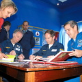
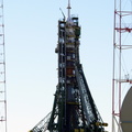
The Human Spaceflight Archive


Information
- Taken in
- Space
- Author
- NASA
- Description
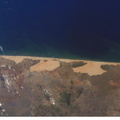
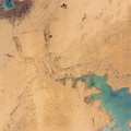
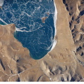
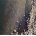
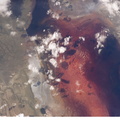
- Lake Nasser and New Valley, Egypt are featured in this image photographed by an Expedition 12 crew member on the International Space Station. Cycles of flood and drought in the African Sahel are legendary, and they have provided the impetus for major waterworks on Africa’s great rivers. The construction of the Aswan High Dam on the Nile River, creating Lake Nasser in the 1960s, is the biggest and most visible project. Heavy rains in the source regions of the Nile in the 1990s resulted in record water levels in Lake Nasser. The abundance of water facilitated the Egyptian government’s promotion of another massive water distribution system called New Valley. In 1997, Lake Nasser flooded westward down a spillway into the Toshka depression in southern Egypt, creating four new lakes over the next few years. Following the initial flooding, a pumping station and canal were constructed in 2000 to maintain water flow into the region, allowing for industrial and agricultural development in the desert. This view shows the completed Mubarek Pumping Station on Lake Nasser; the spillway that originally flooded the Toshka depression and the southern end of the first of the Toshka Lakes; part of the 50-kilometer-long main canal (the Sheikh Zayed Canal); side canals; and several new fields in the Egyptian desert northwest of Lake Nasser. Astronauts, cosmonauts and space-based sensors have been monitoring these developments in Egypt since their inception in the late 1990s. New Valley’s Toshka Lakes, and the new developments surrounding them, represent one of the most visible and rapid man-made changes on Earth’s surface.
- Created on
- Sunday 11 December 2005
- Albums
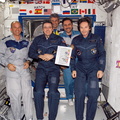
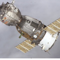
- ISS (WIP) / EXPEDITIONS / EXPEDITION 12
- Source link
- https://www.flickr.com/photos/nasa2explore/albums/72157634842026003
- Visits
- 17
- Rating score
- no rate
- Rate this photo
- License
- CC BY-NC-ND
- Modified by WikiArchives
- No (original)
- Downloads
- 0
Powered by Piwigo